
We have discussed using location to send targeted advertising and interact with customers to improve their buying experience. A further powerful use of location is for internal visualisation and decision making.
This involves using the vast amounts of data you collect about shoppers' behaviour to help plan and target future marketing campaigns for highest return. Using location data in this manner will allow you to target the right consumers in the correct location with the most appropriate offering. You can gain deeper insights into your customers and how they are interacting with your business in ways not possible without the use of mapping visualisation and analysis using the Google Maps Platform to make the correct decisions to grow your business.
Geomarketing for internal decision making
The starting point for using geomarketing for internal decision making is collecting and storing data. Data is the most important ingredient to success so it is absolutely necessary you get this right so the correct 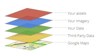 decisions can be made at the other end. There are many different data sources and part of the challenge is getting the most relevant up to date data together and ready for analysis.
Data can come from many different sources from customer data collected at the till or through loyalty cards to information collected from your website detailing where people viewing your site or searching on your store locator are roughly located. Data showing your store locations and your competitors locations can also be pulled together quite easily. Big data sets can also be collected for such things as the location of tweets mentioning your brand and if the sentiment is positive or negative.
This can be combined with 3rd party data such as demographic data, lifestyle, transport or weather information. Once you know what data you have and what is important to you or your customers it can be pulled together and visualised on a map. Here is where the fun begins because you can now start seeing patterns and trends you potentially did not know about but is brought out with the use of location.
Data visualisation with Google Maps
If you have good data that is accurate and easily accessible then the next step is to start visualising and asking questions from this data. Geolocation is key here. It is the one element that can bind the different data sets you have together. Now you can visualise all your different data using Google Maps and location services to give context and associate what were initially disparate data sets.
For example you can view data of where your current customers are located (potentially in a heat map) alongside detailed demographic data such as household income or family size to visualise patterns and trends. You may discover the majority of your customers are located in areas with large student populations for example or in areas close to seaside. These data sets and patterns could not be visualised side by side without the use of a map. This may mean you can target areas with high student population or in close proximity to the seaside as you start to build marketing campaign to win new business and drive the omnichannel experience.
This information and the insights you gain from viewing it on a map can now be used to help drive marketing decision to make sure you are targeting your campaigns at relevant people in the most appropriate location for maximum return. This could include hyper-local ad-serving as an example. Using Google Adwords you can specify if your ad will be shown based on the location of the user. This allows you to only target the people you know are interested or close to what you are offering.
60% of advertising professionals say geo-targeted ads deliver a stronger ROI
But you need to know the locations to target this advertising first, so using geomarketing mapping tools will allow you to make these decisions. This may extend beyond online advertising to the placement of physical advertising or mail drops. Having the correct information to target these activities for maximum return can be hugely beneficial. I discussed geofencing campaigns previously and how important it is to make sure these are relevant and compelling to customers.
For example using geofences and beacons to send targeted advertising. To make sure this is the case you will need to know your customers first and have the correct location data available to make decisions on what messages to send, where and when, to stay relevant and engaged with your users.
By using the latest cloud mapping tools like Google Maps, this information can be made available to the correct decision makers where and when they require it, in real time if needed. Including on mobile devices or in important meetings. The information and insight gained from using these tools no longer has to reside on one computer in a central office or on static paper maps. It can be made available to whoever needs it, when they need it, wherever they are. This in itself can bring huge benefits to the decisions you need to make and help you get full return on everything you do.
Bring together multiple data sets to gain deeper insight
Visualising your data on a map can help you make better decisions to improve your marketing efforts. Bringing together many different and otherwise unassociated data sets on a map can help find patterns and trends you may otherwise not known about.
This can drive decision making and help you make the smartest most informed decisions about any marketing you undertake or other decisions such as where you can expand your business. Location is key to this and if you are not using location you may not be fully informed and losing customers and money.
Working with a Google Maps Premier Partner
As a Google Maps Premier Partner, we can guide you, offer advice on use cases and pricing models across the Google Maps Platform.
For more information about how you can boost your business by adding geolocation and location-based services to your operations, please click here to contact us.
Updated December 2020
First published December 2014